Dodwell: The Obliquity of the Ecliptic
CHAPTER 4
ANCIENT HINDU OBSERVATIONS
Let us now turn to the ancient Hindu observations of the sun’s solstitial shadows. We shall see how they confirm the preceding Chinese results.
At a very early date the ancient Hindus used a vertical gnomon for observation of the solar shadows, in the same way as the Chinese used this instrument. The Surya Siddhanta, one of the most important astronomical works of ancient India, describes the Hindu Observatory of those times. “It consists principally of a level horizontal plane, a floor or terrace of Chunam, which is a lime made from shells, and which, when dried, is hard and capable of receiving a polish equal that of marble. On the surface of the Chunam floor, leveled with water, a circle is described, and a vertical rod of given length is erected at the center as a stylus or gnomon, and by means of the length and direction of its shadow, cast on the plane by the sun, a variety of astronomical problems is solved.”
The earliest record of the obliquity of the ecliptic, determined by the ancient Hindus, is described by C.P.S. Menon in his book Early Astronomy and Cosmology. It is taken from the Jaina Astronomical Treatise called Suryaprajnapti. This text contains estimates of dimensions, such as the size of the celestial bodies, and of the orbits of the sun and moon, and the heights of their orbits.
It can be inferred from the nature of the observations that the ancient Hindus, like the Chinese whose system of cosmology and astronomical measurement was similar, used a gnomon 8 feet in height, and measured the length of the shadows cast by it.
The figures which are given enable the lengths of these shadows at the solstices and equinoxes to be ascertained. These figures are in accordance with the “square cosmology” of the ancient Hindus. (See fig. 7) It is clear that they are derived from measurements of the shadows cast by the gnomon.
In this “square cosmology,” the earth was regarded as standing on a square base, with the diagonals pointing north-south and east-west, and rising in the form of a pyramid to the north pole. The base of the terrestrial pyramid extended to the “four corners (or quarters) of the earth,” and it rose up to “the roof of the world,” and to “Mount Meru, on whose summit lived the gods.” It was believed that in the Meru region, “the day of the angels who inhabit Meru lasts six months, and their night also six months.” (Evidently this represents the North Polar region). Some believed that Meru was one of the snow covered peaks of the Himalayas.
India (Bharata) with Ceylon at its foot, was regarded, in the Suryaprajnapti as the southernmost quarter of the earth, and the northern quarter was another inhabited land, (Airavata), while the eastern and western quarters were believed to be uninhabited lands.
FIGURE 7
The ancient Hindu “square cosmology”
(Polar projection of the earth, assumed as of a pyramidal shape)
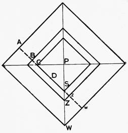
In this figure:
P is the polar projection of the earth’s north pole on the observational plane.
The diagonal, PSZW, is the projection of the meridian, and the other diagonal is the East- West line.
S represents the point on the earth vertically below the sun at mid-day on the summer solstice
Z represents the point on the earth vertically below the zenith at the point of observation.
W represents the point on the earth vertically below the sun at mid-day on the winter solstice.
CS equals the “diameter” of the summer solstitial orbit of the sun, and equals 99,640 yojanas.
Bz equals the “diameter” of the Jambu-dvita (the earth), = 100,000 yojanas.
Aw equals the “diameter” of the winter solstitial orbit of the sun, = 100,660 yojanas.
From these figures,
DS = 49,820 yojanas.
Dz = 50,000 yojanas.
Dw = 50,330 yojanas.
And
Dz - DS = Sz = 180 yojanas.
Dw - Dz = ZW = 330 yojanas.
The distance along the meridian, SZ and SW, are therefore,
SZ = 180 Ö 2 = 254.556 yojanas.
ZW = 330 Ö2 = 486.642 yojanas.
These represent the proportionate equivalents of the shadow-lengths cast at the summer and winter solstices by a vertical gnomon, just as in the similar case of the ancient Chinese observations. They also represent distances on the earth corresponding to the celestial distances of the points immediately above them, on the basis that “the sun’s chariot moves at a height of 800 yojanas above the ground.”
Considering the essential similarity between the ancient Chinese and ancient Hindu systems, it seems very likely that the ancient Hindus also used a gnomon of 8 feet height. The geometrical basis for the calculation of the Obliquity and of the latitude of the place of observation, corresponding to these figures in the Suryaprajnapti, is shown in Fig. 8.
FIGURE 8
Observations of the Obliquity of the Ecliptic, from figures given in the Jaina Astronomical Treatise called Suryaprajnapti.
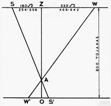
Site of observations: Ceylon
Date of observations: about 945 B.C.
From the similar triangles AZS, AOS' and AZW, AOW',
we have for
height of gnomon...................................AO = 8 feet
length of summer solstitial shadow..... OS' = 2.54556 feet
length of winter solstitial shadow.........OW'= 4.66642 feet
These figures give for the Obliquity, after applying corrections for refractions, solar parallax, and reduction to centre of the sun:
Obliquity = 24° 11′ 04″
And for the latitude of the place of observation:
Latitude = 8° 18′ 32″ N.
The daily circuit of the sun round the earth was considered to be rectangular. The sun, on rising in the east, was thought to move upwards in a straight line to the meridian, and thence in a straight line to the western setting point. Its path was thus parallel to the faces of the earth pyramid, and at a constant distance of 800 yojanas (equivalent to 3784 miles) from the ground.
It was believed that “the motion of the celestial bodies is rectilineal, the circular forms of their daily paths being only an illusion caused by their great distance.”
These ideas made it appear to the ancient Hindus that the geometry of the vertical gnomon, and of the shadows cast by it from the sun, was proportional to the celestial distances, on the assumption that “the sun’s chariot moves at a height of 800 yojanas above the ground.”
A similar estimate formed the basis of the ancient Chinese measurements. According to the Chou Pei, “the image of Heaven is a parasol which envelopes; that of the earth is an overturned basin. Heaven is separated from the earth by a distance of 80,000 li.” This distance of 80,000 li corresponded to 4090 miles, almost the same as the ancient Hindu estimate of the sun’s distance. The sun, however, in the Chinese system, was regarded as moving in circles, gradually widening, and declining in altitude, from the summer solstice to the winter solstice.
The figures given in the Suryaprajnapti refer to two places where observations were made. In addition to the obliquity of the ecliptic at the date of observation, the latitude of the sites of the observations can also be calculated. (Fig. 8)
The obliquity of the ecliptic, thus determined, after correcting for refraction and solar parallax is 24° 11’ 4”.
The latitude of the first place of observation, for which the shadow lengths at both solstices are available, is 6° 18’ 32” North. This indicates a place in Ceylon about 22 miles north of Dondra Head, (latitude 5° 56’ North), the most southerly point of Ceylon. As Mr. Menon points out, we may conclude that these ancient Hindu astronomers “counted the southern extremity of the earth as lying in latitude 6° N. Incidentally, we notice that astronomers had been sent to Ceylon even in that remote age to observe the solstices.”
The second place of observation: Only one observation, namely that of the winter solstice, is given. We can use this, however, to calculate the latitude. The statement of the observation gives room for two alternative sites. One of these is in latitude 20° 15’ 04” North, 14 miles south of Cuttack, near the top of Bay of Bengal; and the other is in latitude 10° 33’ 41” N, corresponding with the latitude of Trichur, 10° 32’ N, in the Cochin Province of S.W. India. This place is the more likely, as it would only require a short coastal expedition to southern Ceylon.
The Suryaprajnapti is said to have been written “sometime about the 5th century B.C., but the cosmological system described in the work apart from a few incongruous elements added to it, is certainly of a much earlier date, some time in remote antiquity when men had not yet begun to regard the circle as the perfect curve, or as providing a scale of angular measurement.”
According to Brennand’s Hindu Astronomy, a notable revision of astronomy was made about 945 B.C., in the time of the famous Princes Rama and Dasaratha, under whom the study of astronomy received much encouragement, and was cultivated with much attention.
Rama was the son of Dasaratha, and is the hero of the great Hindu epic poem called the Ramayana. Reference is made in the Ramayana to the conquest of a part of Ceylon by the hero Rama and his followers, who, according the poem, besieged and took the capital of its King Rawana. No permanent occupation of the country was made at that time, but 400 years later, in 543 B.C., Vijaya, an Indian prince, arrived from the mainland with a small army and established himself as the sole ruler of Ceylon.
It is stated by Bentley, in his Hindu Astronomy, that in the time of Rama, at the Autumnal Equinox, “it was found by observation that the Colures (1)had fallen back in respect of the fixed stars 30° 20’ since the former observations in 1192 B.C.”
This movement is consistent with the earth’s precessional movement in the interval of 247 years, and it is further stated that “In the same period of 247 years and one month they found that the moon had made 3303 revolutions, and one sign over, that there were also 3056 lunations of synodic periods, and the number of days in the whole period was 90245.5.”
Brennand comments, “There is nothing improbable regarding the observations thus stated. They are just the kind of observations the Hindu astronomers were constantly making, to determine the days when the sun was in an equinox or a solstice -- those four days of the year when sacrifices and offerings were to be made to the Supreme Being -- observations which, as expressed by Laplace, resulted in “the remarkable exactness of the mean motions which they (the Hindus) have assigned to the sun and the moon, and necessarily required very ancient observations.”
The ancient Hindu observation of the obliquity of the ecliptic recorded in the Suryaprajnapti, and described in this chapter, falls almost exactly in the middle between the Chinese observations for 1120 B.C. and 700 B.C. These three results form a consistent group, both in the amounts and in point of time. Moreover, they are fully in line with the later results of the Chinese, Hindu and Greek observations.
Hindu value of obliquity derived from the Surya Siddhanta (about 510 B.C.)
The value of the obliquity generally ascribed to the ancient Hindus of a later period than the foregoing is 24° 0’. This was at a date when there had been considerable advances in astronomical theory and practice as compared with the more remote times. This value of 24° 0’ is given by Brennand in Hindu Astronomy pp. 80 and 236, and is taken from the mathematical statements in the ancient Hindu astronomical text book, Surya Siddhanta.
This is one of the best known astronomical works of the Hindus which have come down to the present time, and is written in the Sanskrit language.
It is understood, from its own statements, to have been compiled at the end of the period known as the Trita Yuga, and to embody the science of astronomy as it was at that time; certain changes having been made since more ancient times.
The end of the Trita Yuga corresponds to 510 B.C. The site of the observations is believed to be Hastina Pura, the ancient seat of government in India, in latitude 28° 38’N , a few miles south of Delhi.
The value of the obliquity, according to ancient practice, was determined from the maximum and minimum altitudes of the sun at mid-day at the summer and winter solstices, uncorrected for solar parallax, refraction, and semi-diameter of the sun.
With these corrections added, the final result is 24° 00’ 44”. Reference to Fig. 2 will show how closely this value agrees with the curve at the date 510 B.C. Like the rest of the ancient Chinese and Hindu results, it differs by a large and significant amount from the value calculated from Newcomb’s Formula, namely 15’ 16” higher than that value.
***********************
-
Colures. The hour circles drawn from the celestial pole through the equinoctial and solstitial points on the celestial equator are called the equinoctial and solstitial colure respectively. return to text
continue to chapter 5 |