The Sturtian or "lower glacial" sequence
The importance of the strata in Part 1 is that they form the first of two major episodes in what has been called the “Snowball Earth” sequence of rocks that is found almost worldwide. There are equivalent rock sequences on all six continents. The Snowball Earth theory proposes that the whole earth, including the oceans were covered with thick ice. However, geologists at Adelaide University (among a number of others) have disputed this idea, as there is, for example, evidence for tidal activity and wind-blown sands in the associated rocks.
The initial, or lowest, rocks in the sequence worldwide are diamictites. That is to say those rocks comprise a debris layer made up of angular to sub-rounded rocks of various types in a cement-like matrix. Because it is usually assumed that this debris layer was formed through transportation by ice, it is usually called a ‘tillite’, which has consequent glacial implications. However, there is nothing in this suite of rocks in South Australia that precludes transportation by massive quantities of water moving with great force. Although tsunamis, hurricanes, and dam breaks do indicate that water has the capacity for transporting great quantities of matter, even those examples would not be significant in light of the possibility that something else of much greater force might have occurred. Some disaster movies have been made with this idea in mind, but it is perhaps more interesting to consider what has actually happened in the past.
The diamictite layer in South Australia is about 300 metres thick, and is labelled as “Sturtian” after the Sturt River Gorge in which it is found. Similar rocks are found at the same level elsewhere in the world, and carry this Australian name of Sturtian. This is often referred to as the Sturtian-Rapitan glaciation, because the equivalent Rapitan sequence is found in Canada. Immediately above the diamictite are the sediments which are acknowledged to be deepwater sediments of the Tapley Hill Formation. They total over 2,500 metres thick. In many places in South Australia the Tapley Hill Formation continues conformably (without any evidence for a time break or occurrence of erosion) on top of the diamictite. This indicates that both the Sturtian diamictite and the following deep water sediments are both part of a continuing episode.
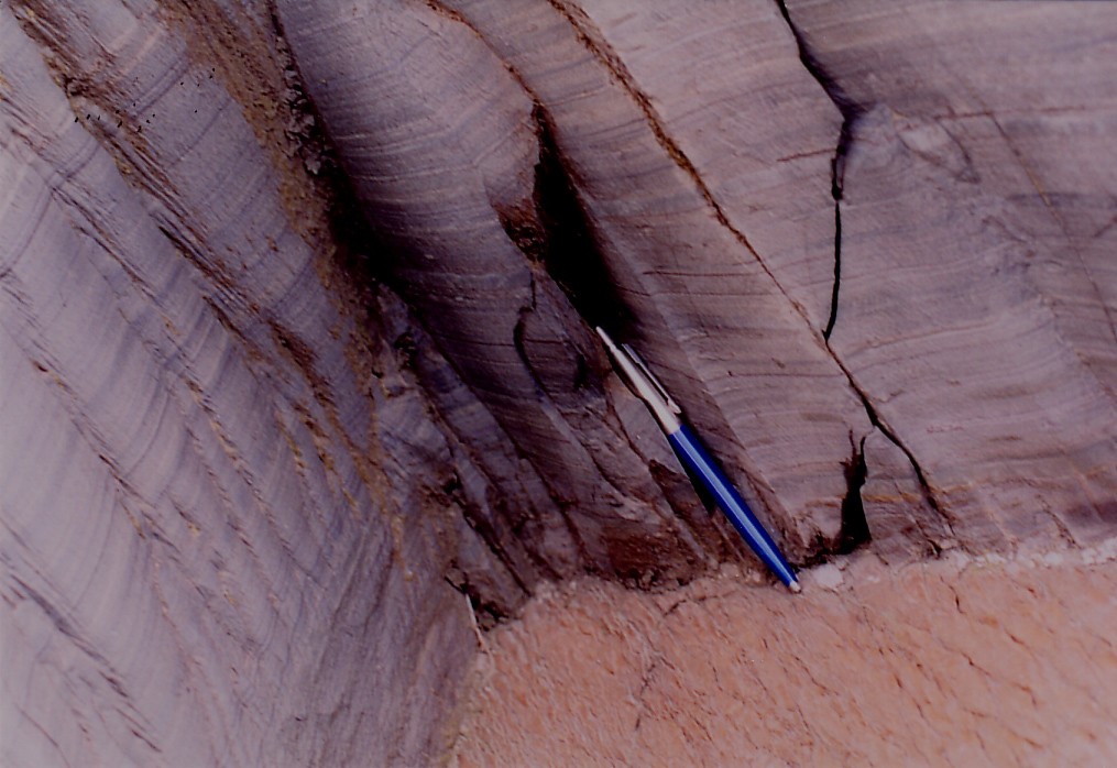
The Tapley Hill Formation is a dark, blue-grey, finely layered siltstone. These fine laminations are “due to variations in mineral composition and pigmentation by organic matter…The darker laminations are stained by organic pigment and contain less quartz silt” [W. V. Preiss, ‘The Adelaide Geosyncline’, p. 162, South Australian Dept. Mines and Energy, 1987]. The light coloured, exposed bedding planes show the presence of “starved ripples” indicating their underwater origin. If this sequence following the diamictite is underwater sediments, and since it lies conformably above the diamictite, then it is also possible that the diamictite itself is not glacial in origin, but due to the action of water.
There is another part of this sequence which also occurs worldwide. It is something called a 'carbonate cap' located on the top of the Sturian-Rapitan sequence. In the Adelaide area of South Australia this is the Brighton limestone. However, in the presentation here, which holds that these strata may represent a catastrophic movement of water, we are focusing on the strata that specifically are the result of that event, namely the diamictite and the deep water sediments above it.
Something which is referred to as a carbonate usually a sign that there was a lot of carbon dioxide. This is not something we would associate with a snowball earth. Carbon dioxide is the result of warm-weather conditions -- a greenhouse environment and possibly a volcanic one. Volcanoes release large amounts of carbon dioxide and so do plants.
Therefore, if there were a snowball earth, something must have changed drastically to produce the kind of carbon dioxide levels which would contribute to the carbonate cap found on the Sturtian-Rapitan sequence. So we can assume that the carbonate cap of the Brighton Limestone represents conditions literally in the middle of this "Snowball Earth" sequence of events, for there is more which is assigned to this sequence on top of the limestone caps. This change in conditions represented by the carbonate cap becomes clear when it is realised that fossilized stromatolite mounds (a type of cyanobacteria mat which builds up over time, usually in warm waters) have been found at the top of the Tapley Hill Formation a little below the Brighton Limestone throughout South Australia. These stromatolites take time to form, but some are over a metre in diameter -- and it is unlikely that they can exist in glacial conditions. For these reasons alone we have reason to doubt the Snowball Earth hypothesis. The photographs below are of the Sturtian sequence in South Australia.
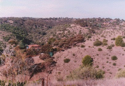
The Sturt Gorge looking east from Flagstaff Hill Road, which is south of Adelaide, South Australia. This whole area in the photograph contains the diamictite layer that is generally known as the ‘Sturt Tillite’ which dates around 720 to 700 million atomic years.
* * *
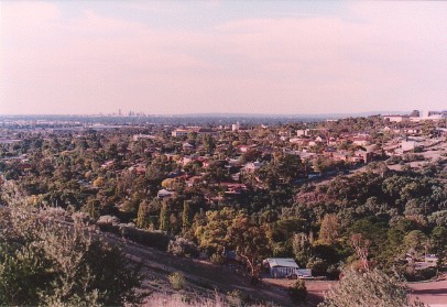
Above is the entrance to the Sturt Gorge looking north from Flagstaff Hill Road. Some of the Flinders University complex and Flinders Medical Centre appear on the hill at the right hand side of the photo. The City of Adelaide may be seen on the skyline in the left-of-centre distance.
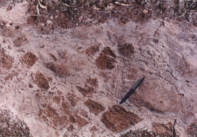
Below is diamictite
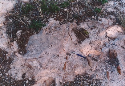
This shows some of the Lower Diamictite with a grey-white dolomitic matrix in the Reserve off Springwood Court, St. Mary’s. The stones within the matrix are called clasts. The size of these clasts can be discerned by the ballpoint pen placed there for comparison. Note that they are still fairly angular. The fact that the matrix in this case is dolomitic means it is a form of limestone (calcium-magnesium-carbonate), and this also may imply warm weather conditions. These clasts originate from the rock strata that immediately underlie the diamictite, namely the Belair subgroup of the Burra Group of rocks, which typically comprise clay-slates, shale and quartzites.
* * *
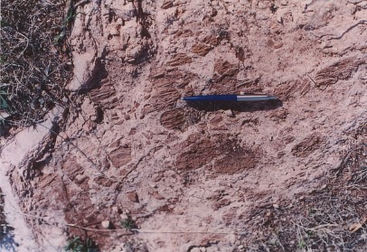
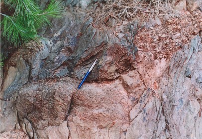
More of the Lower Diamictite is shown above. Note the bedding planes, cleavage, jointing and angularity of these clasts. These features indicate that the underlying rocks from which they were derived must have already been solid for some time before the explosive rush of water tore them off the parent rock and chemically cemented them into this matrix. This means that the Burra Group of rocks, immediately underlying the Sturtian diamictites, had nothing to do with this watery catastrophe. Indeed, there is an unconformity marking a time-gap between the two.
* * *
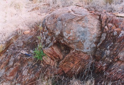
Above is Middle Diamictite with grey-green matrix. Note the large clasts of granite and gneiss. These clasts have been transported over 300 km from the west in an area known to geologists as the Gawler Craton. This is an area of the earth’s surface that had been stabilized considerably earlier. The outcrop photographed here occurs on the southern side of Mill Terrace, St. Mary’s, one of Adelaide’s southern suburbs.
* * *
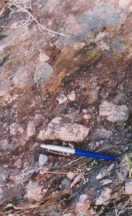
Upper Diamictite with large clasts on the South side of the river in Sturt Gorge. These large pieces of debris also came from over 300 km away to the west. Because of the size of these pieces, it has been assumed that transportation by ice is the most logical method of formation. However, water itself, in a catastrophic situation, is also a feasible method of transportation.
* * *
Close up of the area around the ballpoint pen in in the previous photo showing the multitude of smaller clasts associated with the larger ones.
* * *
Looking down a diamictite exposure in late afternoon sun. The matrix of this uppermost diamictite layer is more crumbly than those lower in the sequence and is weathering away leaving the clasts standing out. The angularity, or sharpness, of the clasts is readily apparent. These pieces of debris are derived mainly from local rocks. The photo was taken on a walkway on the east side of Flagstaff Hill Road above the water tanks.
* * *
Further examples of the uppermost diamictite at the same location as the previous photograph. The more crumbly nature of this matrix is apparent here. This uppermost diamictite layer is sometimes considered to be conglomerate interbeds of re-worked diamictite strata at the base of the following deep water sediments of the Tapley Hill Formation. If this is the case, it is possible that they represent underwater debris flows due to earthquake activity during a catastrophic event..
* * *
Tapley Hill looking west over South Road towards the Expressway cutting, revealing the dark, finely layered Tapley Hill siltstone on top of the diamictite layer.
* * *
The next three photographs form a sequence as the camera goes closer to an outcrop of the Tapley Hill Formation for more detail. In the top photo, the light coloured exposed bedding planes show the "starved ripples" typical of underwater sediments. In the second photo there is a close-up of the finely layered siltstone with the "starved ripples" on top. The siltstone layers are dark because of pigmentation by organic matter, mainly carbon. The ballpoint pen gives a size comparison in the third photo. The photos are taken of an exposure on the east track of South Road, Tapley’s Hill.
* * *
Below is a close-up of the Tapley Hill siltstone showing the fine layers with a five cent piece for size comparison.
These laminations are not varves.
* * *
Layering in the Tapley Hill Formation exposed in the Linwood Quarry of Boral at Brighton, South of Adelaide. This layering is not the result of glaciation. Rather it shows signs of turbulence in the watery environment in which it was laid.
* * *
This photograph is in the Linwood Quarry. The exposed hill in the background shows part of the Tapley Hill formation which continues for over two kilometres to the left of this photograph.
* * *
The above photograph, with the truck on one of the cut roads terracing up the side of the quarry, gives an idea of the depth of the Tapley Hill Formation. The limestone capping is very clear in the photograph below.
The uppermost part of the Tapley Hill formation with the Brighton Limestone above. Just below the Brighton Limestone, large stromatolite mounds have been found. They take time to form, so their presence must mark the boundary between the rock sequences below and the limestone above. Importantly, stromatolites are not likely to form if the water is covered by ice. Stomatolites are rare in the quarry, but more abundant elsewhere at this level in the Formation.
