|
Salt Deposits and the FloodBarry Setterfield, November 2015
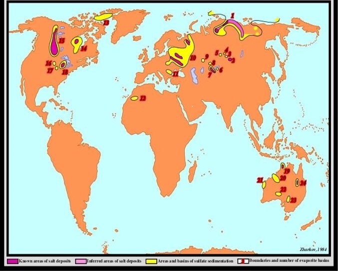
Introduction That name, “evaporite”, comes from the fact that these salts are the ones commonly precipitated when sea-water evaporates. It is thus usually assumed that these geologic salt beds were precipitated in basins that were only erratically open to the sea, so successive layers of salts built up by this evaporation process. Other sediments were then laid down on top of them in these tectonic basins. Eventually the overlying pressure, often aided by the presence of some local fault structure, forced part of the lighter salt formation to rise up and penetrate the rocks above it. This eventually formed a salt dome, or diapir, which reached the surface. If the structure does not reach the surface, it may be discovered during drilling and other geological exploration processes like seismic reflection from underground layers. As far as halite (salt) itself is concerned, the following comment is typical of many. “Roughly 90% of the original volume of seawater must be evaporated before the concentration of the remaining brine is high enough to precipitate halite. So, significant halite production is usually restricted to arid environments in which the influx of seawater is relatively low compared to the loss by evaporation. Since halite dissolves easily in water, halite outcrops typically are only found in very arid environments.” World-Wide Distribution of Salt Beds As we ascend through the geologic column in the Paleozoic we find salt deposits of Ordovician age in the Canadian Arctic Archipelago Basin and elsewhere. Silurian age salt deposits can be found in the Carnarvon and Canning Basins of Western Australia, and the Michigan-Appalachian Basin of the USA, among other places. Then deposits of Devonian age include those found in the East European Upper Devonian Basin, the West Canadian Basin and the North Siberia Basin. The Carboniferous saw salt deposited in a number of basins including the Sverdrup Basin in Canada and the Williston Basin in the USA. In the Permian, salt was deposited in large quantities in many places, including the European Basin, the Central European Basin, the Peru-Bolivian Basin, and the Svederup Basin, all four of which also have volcanics associated with the evaporites. Volcanics may also be associated with other salt deposits mentioned, but I have not had the opportunity to check them. These examples are only some of many basins with large salt deposits in the geologic column from the PreCambrian to Paleozoic. The story goes on into the Mesozoic and Cenozoic, but this gives the general idea of what is happening. A detailed map of the salt deposits from just the Devonian period is shown in Figure 1.
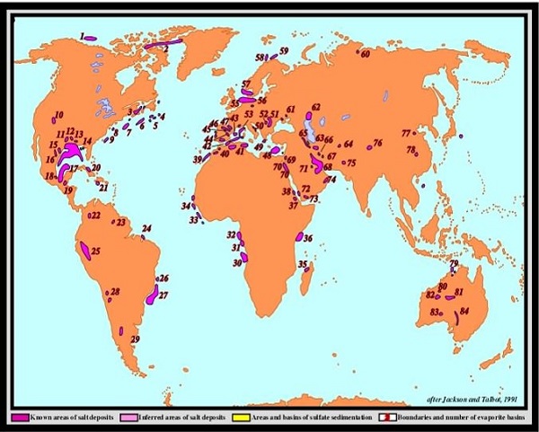
The world map in Figure 2 shows where selected salt deposits of all ages have been noted. However, only those deposits which deformed the strata above them are recorded on this map. This deformation, including salt domes, has been noted by seismic reflection techniques.
Are the Salt Beds all from the Flood? To set the scene, we start in the Cambrian where we find the Deadwood Formation, a sandstone with skolithos burrows. This is typical of similarly located strata around the world where these burrows of some worm-like creature have been recorded in many Cambrian sands. This does not happen in a Flood. The burrows, up to 14 inches long and about one inch wide at the top, take time to form after the sands have been laid down in shallow water. On top of these are other strata, so the burrows indicate a time when deposition had ceased and the creatures had a chance to drill into the sand. So this in itself is an indication that the Flood was not in progress at that point. The following Ordovician Period has a large carbonate formation and above that can be found the Silurian Interlake formation. This formation consists of carbonates, anhydrite, salt, with minor amounts of sand. Throughout the various layers of this deposit are a lot of mudcracks from the drying out of those layers. This sequence of drying out events is unlikely in a Flood. In addition, corals are found here in these Ordovician strata in North Dakota. These may have been just precursors as, to the South-East, in Indiana and Kentucky, a massive coral reef that started in the Silurian and grew on through the following Devonian Period has covered hundreds of square miles. It is in situ on top of older strata and so was not washed into place by a Flood. When the presence of these corals is coupled with the successive layers of mudcracks in Silurian strata in the Williston Basin, then it becomes difficult to see how one Flood can cause these Paleozoic Era strata, let alone the whole geologic column. However, the evidence continues. The following period is the Devonian and in North Dakota the Prairie Evaporite Bed or the Prairie Salt is a major formation of this period and comprises 700 feet of strata. A little above this stratum is the Duperow formation about 1000 feet thick, and still of Devonian age. It is made up of a sequence of limestone, dolomite, anhydrite, and halite repeated 26 times. As part of one limestone bed are some stromatolites, which are dome-shaped mats built up by algae over time in a shallow water environment. These data seem inconsistent with a Flood. In the Williston Basin, Cretaceous strata include the Minnelusa formation which contains a dolomite, a type of limestone formed in hot water, which, in this case, also has desiccation cracks. In other words, conditions were hot and it dried out quickly. In addition, there are two anhydrite beds with an unusual “chicken wire” structure which only forms above 35 degrees C or 95 degrees F. Finally there are desert dune sands with high angles of cross-bedding. These features are not easily reproduced by a Flood. Overlying the Minnelusa formation is the Opeche shale of Permian age. However, at the deepest and central part of the Williston Basin it is a salt deposit 300 feet thick and contains Permian pollen embedded in it. No other pollen types are represented. The area of deposition of the salt is 72,750 square miles which gives a total volume of salt of 2067 cubic miles. Calculation reveals that this amount of salt is contained in 202 million cubic miles of ocean water, or roughly 1/14th of the world’s present oceans. Yet this deposit is nothing compared with the Cambrian Salt Range Formation of Pakistan which is 5000 feet thick. These data not only seem to deny the possibility of the series of strata forming as a result of one Flood, but they also call into question the standard geological assumption that the salt in these basins came entirely from sea-water. Summary of Key Points so far
Initial Conclusion How Did the Salt Deposits Form?
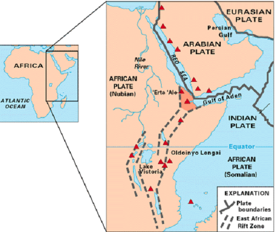
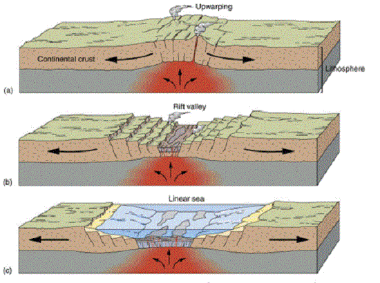
In order to develop this further, we note that in the case of the Peru-Bolivian Basin deposits, and similar structures, it has been shown that intense magmatism (intense magma heating and action) has commonly occurred at depth beneath the floor of these grabens. This may well account for the presence of volcanic material in association with the salt and carbonates. Remember that, according to the ZPE-Plasma Model, the earth interior was heating up with time. Thus there would be a progressive increase in the mobility of these regions, resulting in much heat and an activating fault system. Associated volcanic episodes may be expected. The concept is illustrated in Figure 4.
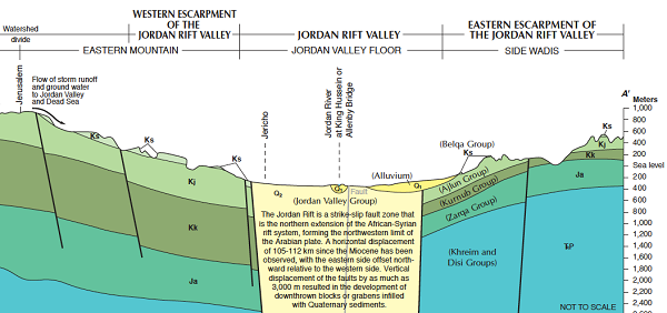
The Example of the Jordan Rift Then the Jezreel segment of the fault block rose again and cut off access to the sea forming a large, land-locked body of water, called Lake Amora. Deposition of different types of sediment then occurred on top of the salt strata. Further changes formed a smaller body of water, Lake Lisan, which also had significant deposition. Finally the much smaller Dead Sea we have today formed as a result of further seismic activity, which dropped the floor of the valley even deeper. One remarkable feature of the area is Mount Sodom, which is made almost entirely of halite. It is effectively a salt dome, 5 miles long and 3 miles wide (8 by 5 km), and is currently rising at the rate of about 1/7th inch (3.5 mm) per year. As far as the salt deposits themselves are concerned, it is generally accepted that volcanic fluids and gases contain CO2-rich and saline-H2O rich solutions as well as HCl and CO. These solutions would be much more concentrated in the earlier history of Earth than now. The reason is that fluids in the mantle were under pressure and in a state similar to supercritical water. This has extreme dissolving power, so many chemicals and salts came to be dissolved in the volcanic fluids as they rose through the mantle. These superheated fluids would then be outpoured into these basins from the underlying magma source. When they hit the cooler sea water, salts and carbonates would precipitate and other chemical reactions would occur, so strata would build up rapidly by this chemical precipitation process. In addition, the sea water with its usual load of salts played a part by a two-fold heating process. First, the magma source under the basin would make the water much hotter than usually expected from solar action alone. If nothing else happened, the water would evaporate much more rapidly than ever expected by ordinary atmospheric processes. If there was no continuing supply of water, so the channel to the sea was temporarily blocked, then it is easily possible for the heating to be such that the basin dried out, desiccated strata and formed mudcracks. This is quite apart from anything that environmental conditions would usually cause. Second, as the superheated magma and volcanic fluids were intruded into the sea water, large amounts of it would evaporate rapidly as steam, and its salt content precipitated. Summary of Salt Bed Formation Mechanism Were the Flood Waters 10 kilometers Deep? Several comments are relevant here. First, because many strata could still have been relatively soft after their formation, this may have enhanced the rising of the salt domes. Second, the depth of strata usually comes from the pouring of sediments into fault-controlled basins, which themselves are dropping over time. The depth of those basins can reach over 6 miles, such as in the Adelaide Geosyncline. Like a block of wood pushed down into a pail of water, as soon as the downward forces stopped, the strata began rising and were upthrust. Therefore, the depth of sediment is not an indication of how high over the earth’s surface the Flood waters rose. Rather it is an indication of the total depth to which the fault-controlled basins had dropped throughout the time that deposition was occurring. An approximate maximum depth around the world appears to be about 10 km. The subsequent uplift of any region may have been partial since all basins have not been fully uplifted. We know this because, during well-drilling, we can still see the strata in the basins going down a number of miles. A Biblical Example In Genesis 14:3 we have an interesting comment. The original document gave names which had been changed by the time Moses copied it. Consequently he made some clarifying editorial statements. One of those is of potentially great interest in the oldest translation available, namely the Alexandrian LXX. There Genesis 14:3 reads “All these [kings] agreed with one consent to meet at the Valley of Siddim; this is now the Sea of Salt.” Additionally, Genesis 14:17 notes that the whole rift valley was also called “the plain of the kings” (LXX) as a number of city-states with their kings occupied the region. This would require a very fertile region to support a relatively large population. There is another point of interest in the Biblical record when the battle took place between the kings from the Rift Valley and those from Mesopotamia. “Now the Valley of Siddim was full of asphalt pits” Genesis 14:10. This is in accord with the geology of the region, as Figure 5 shows the uppermost strata, the Belqa Group, contains oil shale. It seems that this stratum formed the valley floor at the time the kings did battle, as it mentions that the valley itself was “full” of asphalt pits. This layer does not form the valley floor today as it is occupied by the Dead Sea, although it is true that occasionally oily nodules float to the surface. Some conclusions may be drawn from the Biblical and geological data. First, geologically, it was noted that the Dead Sea we have today formed as a result of further seismic activity, which dropped the floor of the valley even deeper than it was in the days of Lake Lisan and its predecessors. The fact that the old “Valley of Siddim” became the “Sea of Salt” might point to this change occurring at the time of Abram. The description of the event is rather graphic in the LXX in Genesis 19:24, 25, 28. “And the Lord rained on Sodom and Gomorrha brimstone and fire from the Lord…And he overthrew these cities and all the country round about, and all that dwelt in the cities, as well as the plants that sprang out of the ground. … And Abram looked towards Sodom and Gomorrha and towards the surrounding country, and saw, and behold, a flame went up from the earth there, as [well as] the smoke of a furnace.” It seems that, associated with the dramatic drop of the fault-block, there was volcanic fire and brimstone and the aerial precipitation of huge quantities of salts from the volcanic gases involved. Abram records that he also saw the smoke of a furnace over the whole region in addition to the volcanic fire and flame. Remember the surface oil-shale deposits? The down-faulting process and resultant volcanism would probably ignite the oil as a dramatic extra to the tectonic activity. Finally, it would be strange if it were only that local part of the rift valley that was involved when such massive activity occurred. To trace concurrent events, it should be noted that the LXX chronology gives a date for the destruction of Sodom and Gomorrah as around 2200 BC. It is interesting that the city-state of Byblos, near the northern extremity of the rift, was also partly destroyed by an earthquake and fire at this time. There is an ash layer two feet thick above the main temple with objects in it which allow the event to be dated as 2200 BC. If the two events were indeed coincident, as seems possible, a 200 mile (320 km) segment of the Jordan rift may have been affected by the process through which salt was deposited in what is now the Dead Sea area.
|