|
New Zealand GeologySeptember, 2016, we received the following email. Barry spend the better part of a week researching the geology of New Zealand in order to respond accurately. Here is the email and his response:
Barry's response: Brief Overview: New Zealand is part of a micro-continent called Zealandia, most of which is under the ocean (Figures 1-3). The country also lies across two moving plates – segments of the earth’s crust (Figure 4). As these plates collide, rocks are being pushed up, creating hills and mountains, including the Southern Alps.
Detailed: New Zealand, New Caledonia and related islands are the visible parts of a larger continental mass known as Zealandia. Today, this micro-continent of Zealandia includes the Challenger Plateau and Lord Howe Rise which stretch from northwest of New Zealand almost to northern Australia. It also includes the Campbell Plateau and Chatham Rise to the southeast of New Zealand as shown in Figures 1 to 3. Figure 4 shows the major source of activity in the region. New Zealand currently sits across two tectonic plates which are converging. The Pacific plate is being subducted (pulled beneath) the Australian Plate from Samoa and Tonga in the north down to Cook Strait and Marlborough Sound in New Zealand. Through most of the South Island the plates are sliding past each other forming the Alpine Fault. The Southern Alps result from this motion coupled with the fact that the Pacific Plate has a slight tendency to thrust over the Australian Plate in that region, pushing up the strata. Finally, from Fiordland southwards, the Australian Plate is subducted under the Pacific Plate forming the Puysegur Trench. In figure 4, the points of the red triangles along the fault zones show the direction of motion of the over-riding plate.
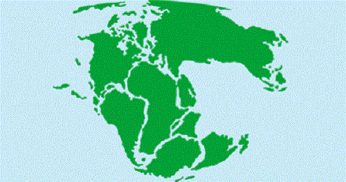
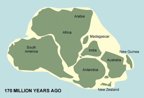
New Zealand and the Original Supercontinent: Much of the basement rock in New Zealand was once part of the southern portion of the original Pangea supercontinent (Figure 5). The northern portion was known as Laurasia, while the southern portion was known as Gondwanaland. This southern section was made up of South America, Africa, Madagascar, India, Antarctica and Australia (Figure 6). Zealandia generally and New Zealand in particular was situated between what is now eastern Australia and western Antarctica as shown in Figures 5 and 6. So the basement or foundation rocks for Zealandia are continental crust which was originally formed as a part of Gondwanaland.
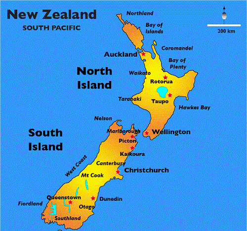
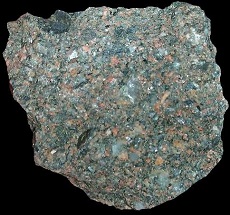
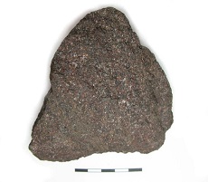
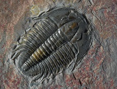
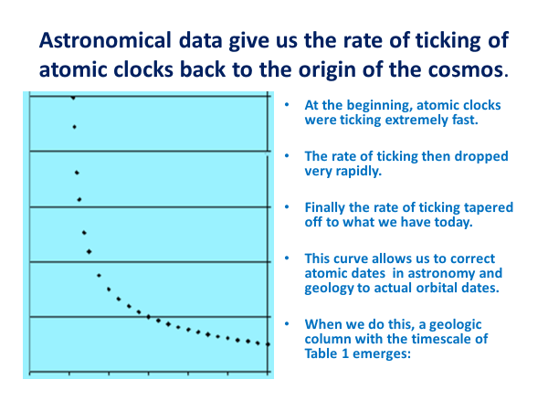
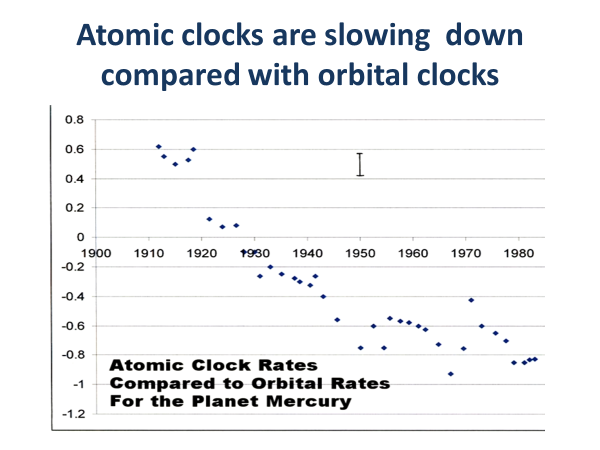
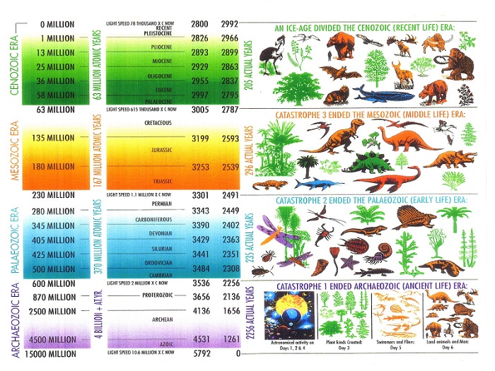
An Initial Explanation: We are all familiar with the vast ages on the geologic timescale. These ages quoted by geologists are all from one or other form of atomic clock. It can be shown, as the Zero Point Energy (ZPE) and Plasma research has done, that all atomic clocks were running much faster initially than now. They therefore register a much older age than is actually the case when time is measured by the orbital period of the earth around the sun. The reason for this faster run-rate is that the electric and magnetic properties of the vacuum have altered due to the expansion of the universe, and atomic clocks in all their forms are based on electric and magnetic interactions. Data from distant galaxies and astronomy reveal what that run-rate was at any time in the past, and this allows a conversion to be made from atomic time to actual orbital time. We quote the atomic times of geology here, but Table 1 (and Figures 9, 10 & 11) give the approximate conversion to orbital dates Geologic strata reveal that there are 4 main Eras separated by 3 Catastrophes making up the geologic column. The earliest Era was the Archaeozoic or Pre-Cambrian, and many parts of Gondwanaland had rocks laid down in this initial Era. However, Zealandia was situated on the southern edge of the supercontinent and did not have the right conditions for this to occur. The 1st catastrophe, “Snowball Earth,” ending 650 million atomic years ago, effectively closed the Archaeozoic Era. The physics of the situation show that water from minerals in the earth’s mantle was being driven out due to radioactive heating. This water had built up under pressure beneath the crust and was explosively outgassed. The trigger for this was the impact of debris from the asteroid belt forming the MAPCIS structure in Australia and cracking the crust. Mars and Venus appear to have had similar episodes. When the correction is applied to this atomic date, it corresponds with Noah’s Flood. Foundation Rocks and the Paleozoic Strata of Zealandia: The Paleozoic Era, which followed the Snowball Earth Catastrophe, therefore started with rushing rivers, massive erosion and huge drainage off the Australian and Antarctic portions of the supercontinent. This carried sediments from those source rocks into the ocean and formed the first or basement strata in Zealandia. These sediments were poorly sorted angular grains of quartz and feldspar and small rock fragments in a mudstone or fine clay matrix. This makes up a muddy gray sandstone type of rock called “greywacke” (pronounced ‘gray-wacky’). The greywacke sequences are generally typical of Paleozoic strata world-wide, and have built up most of the South Island. It is also the basement rock in the North Island, but is mostly hidden under the more recent cover of volcanic material. These earliest rocks date from about 540 million atomic years ago, near the beginning of the Paleozoic Era, in the Cambrian period with its typical trilobite fossils. These fossils can be seen in the Cobb Valley, northwest Nelson. Figure 7 gives the location of key New Zealand cities. Figure 8 shows two types of greywacke (coarse and fine-grained) and a typical trilobite.
Figure 7: Some key cities and regions in New Zealand
Figure 8 Left: Coarse-grained greywacke; Middle: Finer-grained greywacke; Right: A typical trilobite fossil. Somewhat closer inshore to Gondwanaland, and west of the greywacke, was a series of volcanoes stretching as an island arc for 700 miles. For some 200 million atomic years the ash from these volcanoes and the debris from their erosion also built up to the west of the greywacke sediments. The rocks formed from this debris once formed a continuous band, but the movement along the Alpine fault in New Zealand has split these sequences so that they mainly occur from Nelson to south Auckland. These processes continued during most of the Paleozoic until the late Carboniferous or Permian when events associated with the Permian catastrophic extinction occurred. This event, about 250 million atomic years ago, closed the Paleozoic Era and is the equivalent of the Babel catastrophe in the Bible. At that time earth movements and heat buckled, folded and changed some of these sediments into “metamorphic” rocks, or rocks which have been altered by heat. In other places the heat completely melted the rock which recrystallized as granite and diorite. These crystalline rocks can now be found along the west coast of the South Island. The Mesozoic Strata of Zealandia: By the time of the upheaval at the Permian extinction, the Plasma-ZPE Model suggests that the earth interior was heating up very significantly from radioactive decay processes. This heating is evident in the strata of the Mesozoic Era which followed that 2nd Catastrophe. In addition, the massive impact, which triggered the Permian Extinction itself, occurred in Wilkes Land, Antarctica, and left a crater 300 miles wide. There were several results from this impact. First, the pressure wave went right through the earth and at its exit at the antipodal point it caused the massive lava outpouring known as the Siberian Traps in the northern sector of Laurasia. Second, this massive volcanic episode, and other lesser events, gave a very significant increase in the CO2 content of the atmosphere. Third, a series of fault-blocks was formed which progressively mobilized as the heating of the earth’s interior continued, making magma plumes. Fourth, these events also had ongoing repercussions for the geology of the region which formed New Zealand, since that was situated off the south-eastern edge of Gondwanaland, and so was not that far from the focus of the Wilkes Land impact. As an outcome of these events, the crust in this region down-warped and fault troughs dropped. This resulted in the sediments they had gathered, including some basement greywacke, being heated and metamorphosed. They were then uplifted in a process which went on from 200 million to 160 million atomic years ago. The metamorphosed rock in this case is called “schist” and the Haast Schist from this event can be found as bedrock in Otago and Southland. It also outcrops as a narrow band on the western edge of the Southern Alps. As the earth’s mantle became hotter and more fluid, molten rock was intruded into the 1000-mile-long mountain range that had formed on the edge of Gondwanaland. It hardened to become granite, some of which outcrops in the Abel Tasman National Park. This event is dated as about 100 million atomic years ago. However, around this long mountain range were lush lowlands which grew in size as the mountains eroded rapidly. Vegetation grew more prolifically back then due to different environmental conditions, including the high CO2 content, and different vacuum properties. The mantle heating then mobilized the fault blocks which dropped causing churning tsunamis which swept the vegetation into these troughs. This formed the coal sequences now found in Otago, Southland, Westland and Nelson. Elsewhere the erosional debris from the mountains washing down into the ocean fossilized both the land dinosaurs and their water-dwelling cousins. A series of at least seven major asteroid impacts, one of the largest of which was in the Yucatan leaving a crater 130 miles wide, ended the Mesozoic Era. This event about 65 million atomic years ago also decimated the dinosaurs. This 3rd Catastrophe is called the Cretaceous-Tertiary (or K/T) extinction and has left its evidence in the form of a clay layer rich in iridium from the asteroids and with a high carbon ash content from the resulting global wild-fires. This clay layer can be seen at places like Woodside Creek in Marlborough. These processes of asteroid impacts coupled with high mantle temperatures and mobility impelled the continental plates to drift apart. This process has now slowed very significantly but is nonetheless ongoing. Genesis 10:25 says that this continental division first started in the days of Peleg and this agrees with the Plasma-ZPE Model dating when atomic dates are compared with actual orbital dates. Cenozoic Strata of Zealandia: As the continental separation began, a sizeable chunk of Gondwanaland broke off. This included some inland areas of older rocks as well as the more recently developed coastal regions. This chunk moved off into the Pacific Ocean and Zealandia, about half the size of Australia, had become a continent in its own right. The new region of ocean in the west eventually became the Tasman Sea. As Zealandia moved away from the heating in Gondwanaland, its rocks cooled and became more dense. As a result, it gradually sank lower. But during that time, the churning tsunamis generated by the motion of the Zealandia continent ripped up near-shore vegetation and deposited it in nearby fault-controlled basins. This formed the major coal deposits found at Greymouth, Buller and Waikato. Meanwhile, sandstones and mudstones and other sediments were deposited on the shallow, but sinking, shelf areas. In the calmer areas, extensive limestone deposits were formed which are used today as Oamaru’s building stone and also offers a scenic attraction at Pancake Rocks on the West Coast at Punakaiki. Parts of the North Island still retain some of this sedimentary sequence, but on the South Island most of this cover has now been eroded away. By 35 million atomic years ago, only about one third of modern New Zealand was above the water as a series of islands. But then another event happened. From about 25 down to 5 million atomic years ago, the motion of the Australian and Pacific plates was such that New Zealand’s great Alpine Fault developed. The side-swipe collision between the tectonic plates pushed up the mountains and Alps, caused extensive volcanic activity and forced up land from beneath the sea. In addition, huge basaltic volcanoes formed what is now the Banks and Otago peninsulas, while Dunedin sits on an eroded volcano from this period. The Lyttleton, and then the larger Akaroa volcanoes date from this time. The Coromandel peninsula saw much volcanic activity which only died down at the beginning of the last ice-age, about 2.5 million atomic years ago. The rapid erosion of these mountains and volcanoes formed a soft, loose type of surface rock which makes up many of the hill areas of the North Island, and has sometimes been called “Papa Rock”. Because of the impacts which closed the Mesozoic, the following Cenozoic Era, which we are still in, had an initially high axis tilt. As the effects of impact wore off, this high tilt caused temperatures to progressively drop around the world until the last ice-age set in. This started about 2.6 million atomic years ago and reached a peak about 1.8 million atomic years ago. It finalized about 10,000 to 13,000 atomic years ago. In this time, glaciers developed on the mountains in New Zealand and carved out the landscape from Fiordland to West Nelson, with smaller glaciers on the Tararua and Ruahine ranges of the North Island as well as on the central volcanoes. When the iceage ended, some of the deposits of rock debris left by the retreating ice (called “moraine”) acted as dams and form some magnificent lakes such as Te Anu, Wakatipu, Tekapo and Pukaki. On the South Island’s West Coast, ridges of moraine hundreds of yards high extend down to the coast and out under the sea. Meanwhile, rock debris from the glaciers has also been washed down rivers and filled the river valleys with thick gravelly deposits. The ice-age ended when the earth’s axis tilt was suddenly decreased by another impact event researched by the late Government Astronomer for South Australia, George Dodwell. From ancient records in orbital time, this event occurred in 2345 BC +/- 150 years and affected ancient civilizations around the world. In atomic time this event dates as about 10,000 BC. This event basically brings us right up to the present geologically. Finally, a chart comparing atomic time with orbital time may be helpful and is presented as Table 1. Table 1: Comparison of events in atomic time and orbital time
Figure 11: A Geologic Chart giving approximate geologic dates and orbital time correction as in this article.
|


